When we introduced Small City Mapping, our goal was to help customers work at the right level of geographic granularity, mapping smaller cities and suburbs to the major metropolitan areas they belong to so teams can target key markets without manually managing every surrounding city or neighborhood.
Today, we’re introducing the first round of enhancements to our Big City/Small City Offering, delivered through the existing Small City Mapping decode file available in the Support Portal. Rather than simply expanding coverage, we’ve rebuilt how metropolitan relationships are defined across 25 priority countries using country-specific research and authoritative statistical sources.
This work reflects a significant, ongoing investment of time, research, and resources in strengthening our worldwide geographic intelligence, bringing more local context to our existing data and laying the foundation for additional refinements in future releases. That investment has enabled Digital Element to become the only provider offering Big City/Small City mapping built through country-specific research and authoritative statistical sources. We make that investment for a simple reason: better data drives better outcomes for our customers.
Refining How “Big” and “Small” Are Defined
Our original mappings were developed using a standardized methodology applied consistently across countries, providing efficient worldwide coverage and a common framework for classification.
As we’ve continued working with customers around the world, we recognized an opportunity to go further. Metropolitan regions are defined differently from one country to the next, and a single global methodology can’t always capture those local distinctions.
For each of the 25 countries included in this release, our team invested in original, country-by-country research, working directly from authoritative government and statistical sources to determine:
which cities should serve as major metropolitan centers
how surrounding cities, suburbs, and municipalities should be associated with those markets
The result is a significant refinement of our existing Big City/Small City mappings that better reflects how metropolitan regions are actually organized within each country. It’s one example of our continued investment in improving geographic intelligence as customer needs evolve.
The First 25 Countries
This round targets the countries that either have Metro-level support within NetAcuity today or where we see clear customer demand:
Australia, Belgium, Brazil, Canada, China, Denmark, Finland, France, Germany, Iceland, India, Indonesia, Italy, Japan, Luxembourg, Netherlands, New Zealand, Norway, Poland, Russia, South Korea, Spain, Sweden, United Kingdom, and Vietnam.
Additional countries already planned as this initiative expands across our worldwide coverage.
Big City/Small City Mapping Example: France
France illustrates the scale of the refinement. The previous mapping classified 320 French cities as “big.” Rebuilding the mapping against INSEE‘s Urban Attraction Areas (AAV 2020), France’s official statistical geography for urban influence zones, produced a revised list of 172 big cities, with the remainder correctly reassigned as small cities tied to the appropriate metropolitan area.
Metric
Before
After
Change
Big Cities
320
172
−148
Small Cities
30,106
30,261
+155
Total Rows
30,447
30,447
—
While every country requires a different methodology, France demonstrates the impact of applying country-specific research instead of relying on a single global approach. Similar refinements were made throughout this first group of countries using each nation’s own authoritative geographic definitions.
France was not unique. We observed similar patterns across the countries reviewed, reinforcing the value of aligning each country’s mappings with authoritative local statistical sources.
What This Means for You
No action is required to benefit from these refinements:
Same file, better data. There is no new file or product name — the existing Small City Mapping decode file on the Support Portal will be updated with the revised mappings.
Preview available. If you’d like to review the changes before they go live, we can provide before-and-after versions of the Small City Mapping decode file. Contact your Client Success representative.
Feature Code 93 included. If you use the NetAcuity Server with Feature Code 93 (the Decode DB), all fields sourced from the Small City Mapping decode file will automatically reflect the refined big/small mappings.
A Stronger Foundation for Every Use Case
These enhancements are about more than refining city classifications. They reflect the substantial time and resources Digital Element continually invests in its data—building geographic intelligence, country by country, through original research no off-the-shelf dataset replicates. We do that work so our customers get more accurate results from the same products they already use.
As additional countries are incorporated into this initiative, customers will continue to benefit from richer local context without changing the way they access or use Small City Mapping.
This is the first step in a broader effort to continually strengthen our worldwide geographic data—an investment that pays off where it matters most: helping customers make better location-based decisions with greater confidence.
Contact your Digital Element Client Success Representative to learn more or request a before-and-after review of the refined mappings.
If you’ve ever tried to make a critical decision based on IP intelligence — whether that’s targeting an ad, stopping fraud, enforcing content licensing, or investigating suspicious activity, you already know one thing: IP data is only as valuable as your ability to interpret it correctly.
And increasingly, that’s becoming harder.
As the internet continues to evolve, IP addresses are no longer a clean one-to-one signal tied to a single user, device, or location. More and more often, multiple subscribers may appear to share a single public IP address, which can distort location accuracy, dilute risk signals, and complicate identity-based decisioning.
That’s why Digital Envoy introduced NAT Detector — a proprietary backend process within NetAcuity designed to identify NAT-enabled networks and shared-IP environments (including large-scale, carrier-grade deployments). NAT insights are processed and surfaced directly within our NetAcuity Connection Type database as a dedicated call-out: “nat” — giving teams critical context for more accurate, reliable decisioning in a shared-IP world.
Why shared IPs are becoming the norm
Network Address Translation (NAT) has been a foundational part of networking for decades. At its core, NAT allows multiple devices to share a single public IP address — a capability that’s extremely common in home, enterprise, and managed network environments.
But what’s changed dramatically in recent years is the scale.
As the global supply of IPv4 addresses has dwindled, many internet service providers (ISPs) and mobile carriers have accelerated their use of Carrier-Grade NAT (CGNAT) and other shared-IP strategies. In simple terms: more users are being routed through fewer public IP addresses.
This approach helps networks stay operational, but it also introduces new challenges for businesses that rely on IP intelligence for precision, trust, and enforcement.
The challenge: IP behavior is changing
For years, IP intelligence has served as a cornerstone signal across industries. But today, traditional assumptions about IP-based identification — such as uniqueness and stability — are becoming less reliable.
In high-value decisioning environments, that matters.
When many users share the same outward-facing IP address, it can lead to issues like:
Reduced geolocation accuracy
Inconsistent attribution and measurement
Unstable device and identity signals
False positives in fraud and cybersecurity systems
Compliance and licensing friction for legitimate users
Put simply: it’s not enough to know where an IP appears to be — you need to understand how it behaves.
As Digital Envoy Chief Product Officer Vinod Kashyap puts it:
When NAT connection is in play, an IP address may represent multiple users, subscribers, or endpoints. NAT Detector helps surface that insight directly, so teams can:
improve geolocation precision
better contextualize IP-level activity
make decisions based on more realistic IP assumptions
reduce reliance on fragile “one IP = one user” logic
When NAT is detected, NetAcuity will explicitly identify the connection type as “nat,” making it easy to flag shared-IP environments in downstream workflows.
This matters because NAT doesn’t just affect location, it can impact the reliability of every downstream signal derived from IP data.
How NAT detection improves decisions across industries
NAT Detector isn’t limited to one market. It supports a wide range of use cases where IP intelligence plays a central role — especially when accuracy, trust, and performance are on the line.
Adtech & Marketing: more accurate targeting and measurement
In advertising and marketing environments, IP is often used for:
audience segmentation
regional targeting
contextual decisioning
measurement and modeling
But if a public IP address is actually shared across many subscribers, it can inflate or distort assumptions about who’s behind a given signal.
With NAT Detector, teams gain clearer insight into when an IP address may not represent a precise geographic user — improving targeting quality and helping reduce misinterpretation across campaigns.
Fraud and security teams often look at IP behavior as part of:
risk scoring
threat analysis
anomaly detection
enforcement decisions
But shared infrastructure changes the picture. When traffic originates from NAT-enabled environments, traditional IP-level signals can become diluted.
NAT Detector helps strengthen decisioning by highlighting when traffic is tied to shared IP infrastructure, enabling more accurate risk interpretation and more resilient scoring.
DRM & Content Licensing: stronger enforcement with fewer false flags
Streaming platforms, publishers, and content providers commonly use IP-based signals for:
licensing enforcement
regional restrictions
compliance checks
But NAT and CGNAT can create a mismatch between IP-based location and real end-user location, resulting in friction for legitimate viewers — or allowing unauthorized access to slip through.
NAT Detector helps teams identify potential discrepancies and make smarter enforcement decisions without over-relying on “IP location = user location” assumptions.
Fintech & Compliance: sharper interpretation for high-stakes flows
In fintech and compliance environments, confidence is everything. Teams rely on IP intelligence to support:
fraud prevention
transaction risk analysis
KYC / KYB workflows
compliance validation
When IP addresses represent shared NAT environments, behavior signals can become harder to interpret — especially in workflows built around uniqueness or consistency.
By identifying NAT-associated connections, NAT Detector supports more refined interpretation of IP address behavior, improving outcomes in both fraud detection and compliance decisioning.
A more realistic foundation for modern IP intelligence Insights
The shift toward shared IP address environments isn’t a temporary trend — it’s a structural change driven by real-world pressures like IPv4 scarcity and expanding global connectivity.
That means the future of IP intelligence will be defined not only by “where” an IP appears to be, but also what it represents in today’s network conditions.
NAT Detector helps address that reality — delivering a more accurate foundation for teams that need dependable IP-based decisioning at scale.
To see how NAT Detector can improve your IP decisioning, reach out to our sales team here.
FAQs
What is NAT Detector?
NAT Detector is a proprietary backend process within Digital Envoy’s NetAcuity that identifies NAT-enabled and carrier-grade NAT (CGNAT) environments. These NAT insights are processed and surfaced in the NetAcuity Connection Type database as a specific call-out: “nat” — enabling more accurate interpretation of IP intelligence in shared-IP conditions.
What is NAT (Network Address Translation)?
Network Address Translation (NAT) is a method that allows multiple devices or subscribers to share a single public IP address, which is common across home networks, enterprises, and ISPs.
Why are shared IP addresses increasing?
Shared IP addresses are becoming more common due to IPv4 scarcity. Many ISPs and mobile carriers use carrier-grade NAT (CGNAT) to route more users through fewer public IPv4 addresses.
How does NAT impact IP geolocation accuracy?
NAT can reduce IP geolocation accuracy because a single public IP address may represent many different users, devices, or locations—making “one IP = one user” assumptions less reliable.
How does NAT detection help with fraud prevention and cybersecurity?
NAT detection helps security and fraud teams better interpret IP address behavior by revealing when traffic comes from shared-IP environments, reducing blind spots and improving risk decisioning.
How does NAT affect ad targeting and marketing analytics?
In marketing, NAT can distort IP-based audience signals and regional targeting because shared IPs may represent multiple users. NAT Detector provides added context for more accurate targeting and measurement.
How does NAT impact content licensing and streaming enforcement?
NAT and CGNAT can create location ambiguity, which may lead to licensing friction or false enforcement. NAT Detector helps platforms interpret IP location signals more realistically.
How does NAT detection support fintech and compliance teams?
Detecting NAT-enabled networks helps fintech and compliance teams interpret IP address behavior more accurately in shared-IP environments — strengthening risk decisioning in fraud prevention, KYC/KYB workflows, and regulatory compliance flows.
When a user logs in, clicks an ad, or completes a transaction, their IP address is one of the first pieces of information available. It’s immediate, universally present, and incredibly telling—if the data behind it is reliable. Across industries, IP geolocation is used to deliver localized experiences, detect fraud, enforce content rights, assess risk, and make thousands of real-time decisions each second.
But IP data is only as valuable as it is accurate. While many solutions provide basic IP-to-location mapping, what truly drives performance and trust is high-quality IP geolocation data enriched with context, behavior, and network-level visibility.
The Critical Role of Accuracy
Location-based decisions have significant implications. Consider an ad campaign targeting users in a specific metro area. If the IP data is even slightly inaccurate—misclassifying suburban users as urban dwellers, or misplacing mobile IPs across state lines—the performance of that campaign drops dramatically. Impressions are wasted. Attribution data becomes unreliable. Budget efficiency suffers.
The same applies in regulated industries such as online gambling, where accuracy is non-negotiable. A betting platform that misidentifies a player’s location could allow wagers from a jurisdiction where gambling is prohibited—exposing the company to severe compliance penalties and reputational damage. Similarly, a fintech company that fails to flag mismatched geolocation during a transaction could open itself to unnecessary risk or regulatory scrutiny.
These aren’t edge cases—they’re everyday operational realities. The margin for error is slim, and the consequences of getting location wrong ripple throughout the entire digital stack.
What Sets High-Quality IP Data Apart
High-quality IP data goes far beyond matching an IP address to a city. It’s built from a dynamic, multilayered system that incorporates hourly updates, behavioral insights, and infrastructure-level context.
Frequent updates are essential. IP addresses—especially those used by mobile carriers or rotating proxies—change constantly. Without a data source that refreshes, at a minimum, weekly, organizations risk making decisions based on outdated or misleading information.
Another key differentiator is the presence of behavioral and structural indicators. High-quality IP intelligence reveals more than just geography—it identifies how many devices are behind an IP, how often it moves, whether it’s associated with residential or commercial infrastructure, and if it’s ever been linked to anonymization tools like VPNs or proxies. This depth of insight empowers businesses to assess risk, target effectively, and personalize responsibly.
Network intelligence also plays a major role. Knowing which autonomous system (ASN) owns the IP, whether it’s tied to a mobile network or cloud host, and what kind of traffic behavior it typically supports helps companies separate normal user activity from potential threats or anomalies.
Why Basic IP Data Falls Short
Many businesses rely on off-the-shelf IP data that prioritizes breadth over depth. These datasets are often aggregated from third-party sources, updated infrequently, and lack transparency into how locations are derived. This can result in major inconsistencies—like identifying rural IPs as city-based or missing major reassignment events due to ISP reallocation.
What seems like a cost-saving choice often creates more problems down the line. Misattributed geolocation leads to misinformed decisions. Flagging the wrong users as suspicious erodes trust. Showing the wrong content or blocking access for legitimate customers leads to churn.
Ultimately, basic IP data isn’t just a weak link—it’s a liability.
The Strategic Advantage of Getting It Right
Investing in high-quality IP geolocation data gives organizations the confidence to act quickly and the clarity to act correctly. Whether it’s approving a login, launching a campaign, serving regional content, or verifying a user’s location, those decisions are stronger when powered by trustworthy data.
It’s not just about location—it’s about understanding the digital environment an IP represents. The more context you have, the better your systems perform, the smoother your user experiences become, and the more efficiently you can manage risk.
Ready to Power Smarter Decisions?
Digital Element delivers industry-leading IP intelligence that goes beyond location–providing the context, accuracy, and real-time visibility that organizations need.
When it comes to IP address geolocation, the numerous use cases that our customers employ require data to be parsed in many different ways. We often find ourselves playing a game of geographical Goldilocks, looking for the level of IP granularity that is not too big, not too small, but juuuuuust right.
Here are some examples of how challenges with city-level precision in the NetAcuity Pulse IP geolocation database can translate into real-world operational and user-experience issues:
Giving website visitors a drop-down of city names to choose from, and the NetAcuity database returns an overly long list
IP to city-level targeting where the city response is too granular for practical market-level use
Using NetAcuity for Flat File deployments where there are too many rows or IP ranges to ingest due to city-level IP range fragmentation
Based on scenarios like this, Digital Element set out to solve this challenge. To do so, our team mapped small cities and suburbs around the world to the larger metropolitan areas that they fall within. This enables Digital Element customers to target major metropolitan areas without having to identify and manually select every surrounding suburb or neighborhood.
As outlined in our blog The Tricky Science Behind IP GeolocationIP address density in a major city often fails to reflect the true population of its surrounding metropolitan area, particularly when addresses are correctly assigned to nearby suburbs.
Small City Mapping
To meet the needs of our customers’ wide range of use cases and reduce operational complexity, Digital Element introduced Small City Mapping. This capability allows customers to convert an existing “small city” response from the Pulse city field into its associated larger metropolitan city, saving time, simplifying logic, and improving usability.
To demonstrate how this works, let’s use India as our geographic example and apply it to a common use case mentioned above: reducing overly long city selection lists.
Imagine you’re on the web development team for the IKEA India website, building a store locator for visitors. IKEA typically operates stores in major metropolitan areas, so visitors from surrounding cities need to be mapped accurately to the nearest metro where a store exists.
One of India’s 28 regions, Maharashtra (MH), contains approximately 350 cities. Asking users to manually scroll through hundreds of city options creates unnecessary friction.
Using Small City Mapping, visitors whose IP addresses fall within smaller surrounding cities are automatically associated with the closest major metropolitan area, ensuring relevant store locations are displayed instantly.
Here is an example of IP address traffic observed on the IKEA website.
IP Address
1.6.35.225
1.6.35.125
1.6.35.19
1.22.44.22
1.22.52.81
1.22.102.218
1.22.9.152
1.22.80.73
1.22.80.196
The web development team can query these addresses against the NetAcuity database to determine the Region, City, and City Code associated with these IP addresses. Below is what NetAcuity will return.
Start IP
End IP
Country
Region
City
Metro
City-Code
1.6.35.0
1.6.35.255
ind
mh
andheri
356002
148717
1.22.8.196
1.22.8.196
ind
mh
andheri
356002
148717
1.22.80.251
1.22.80.251
ind
mh
andheri
356002
148717
1.22.44.16
1.22.44.63
ind
mh
bandra west
356002
246533
1.22.52.81
1.22.52.81
ind
mh
bandra west
356002
246533
1.22.102.218
1.22.102.218
ind
mh
bandra west
356002
246533
1.22.9.152
1.22.9.152
ind
mh
dharavi
356002
148743
1.22.80.72
1.22.80.73
ind
mh
dharavi
356002
148743
1.22.80.196
1.22.80.196
ind
mh
dharavi
356002
148743
The cities associated with the IP addresses from web traffic were Andheri, Bandra West, and Dharavi. The web development team can then use the Small City Mapping decode file To determine what big cities these three smaller cities map to.
Country
Region
City-Name
Metro-Code
City-Code
Big-Small
Big-City-Name
Big-City-Code
ind
mh
andheri
356002
148717
small
mumbai
34785
ind
mh
bandra west
356002
246533
small
mumbai
34785
ind
mh
dharavi
356002
148743
small
mumbai
34785
As you can see, the IP address ranges all map to Mumbai as the big city. Because these small cities all map to Mumbai, logic can then be built into the website to ensure that visitors from any of the IP ranges that correspond with these cities are shown the Mumbai stores when using the store locator tool.
In any cases where IP address ranges are consecutive, the rows will be consolidated.
Start IP
End IP
Country
Region
City
Metro
City-Code
1.6.34.0
1.6.34.255
ind
mh
mumbai
356002
34785
1.6.35.0
1.6.35.255
ind
mh
andheri
356002
148717
Small City Mapping decode result:
Start IP
End IP
Country
Region
City
Metro
City-Code
1.6.34.0
1.6.35.255
ind
mh
mumbai
356002
34785
How This Enables Modern, Cookieless Use Cases
A/B testing content by market using IP context Small City Mapping allows teams to test messaging, layouts, or offers at the metro level instead of fragmented city responses. This produces cleaner experiments, more reliable attribution, and consistent market definitions without relying on cookies or logged-in users.
Cookieless geo-targeting with trustworthy measurement Because NetAcuity uses authoritative IP intelligence rather than user-declared location, organizations can localize experiences while maintaining consistent, privacy-forward measurement, especially critical as third-party cookies continue to disappear.
Minimizing false blocks in live sports streaming Overly granular or misaligned city-level targeting can lead to accidental content blocks. By mapping suburbs and small cities to their correct metro areas, Small City Mapping helps streaming platforms enforce regional rights accurately while reducing false positives that frustrate legitimate viewers.
How to Access the Small City Mapping Decode File
The Small City Mapping Decode File is available to all Digital Element customers at no additional cost and can be accessed in the following ways:
Downloadable via the Digital Element support portal on the Decode Files page as a .tab or .csv file
Loadable into a local database and usable across NetAcuity deployment options, including Server/API, Flat File, Embedded API, and Cloud Service
Customers using NetAcuity Server/API, Flat File, or Cloud Service can query or dump Feature Code 93 (Decode DB) and Feature Code 26 (Pulse) to automatically populate big-city mappings
Feature Code 93 mirrors the fields in the Small City Mapping Decode File and can be licensed through the Client Success team.
In the coming months, we will be introducing Feature Code 93 which will enable DE customers to make a single query or create a flat file where there is a dedicated field to the existing “pulse-city” and the “decode-big-city”. This new Feature Code will produce an industry-first data set that returns two locations for a single IP address: the small city that the IP address is located, and the larger metropolitan city that it is associated with.
Frequently Asked Questions About Balancing IP Precision with User Needs
How can I A/B test content by market using only IP context?
By using NetAcuity IP geolocation with Small City Mapping, teams can group users into consistent metropolitan markets based on IP address alone. This enables clean A/B testing across defined regions without cookies, logins, or self-reported location data.
Can Digital Element support cookieless geo-targeting?
Yes. Digital Element’s IP-based geolocation enables location-aware content delivery and measurement without relying on cookies. This supports privacy-forward targeting while maintaining reliable geographic attribution.
How does Digital Element reduce false blocks in geo-restricted live streams?
Small City Mapping ensures that IP addresses in surrounding suburbs are accurately associated with the correct metropolitan area. This reduces accidental blocks caused by overly granular city-level enforcement while still respecting regional content rights.
What level of IP granularity does NetAcuity support?
NetAcuity supports country, region, metro, city and postcode y-level targeting, globally. Small City Mapping adds flexibility by allowing customers to operate at the most appropriate geographic level for each use case.
How does Small City Mapping improve user experience without sacrificing accuracy?
Small City Mapping preserves precise IP placement at the city level while allowing organizations to present cleaner, more intuitive experiences—such as simplified city lists, metro-level store locators, or regional content groupings. This balance helps reduce user friction without compromising the underlying accuracy of NetAcuity IP data.
Can Small City Mapping help simplify IP data ingestion and processing?
Yes. By consolidating multiple small-city IP ranges into their associated metropolitan areas, Small City Mapping can reduce IP range fragmentation and row counts in flat files or databases. This makes IP data easier to ingest, manage, and operationalize across analytics, targeting, and enforcement workflows.
Choosing the Right Level of IP Geolocation Granularity
Effective IP geolocation isn’t about choosing the smallest possible data point, it’s about choosing the right one for your business goals. Digital Element helps organizations localize experiences, test markets, and enforce regional rights with confidence, accuracy, and scale.
If you’re evaluating how IP geolocation can support cookieless targeting, reduce false blocks, or simplify market-level decisioning, our team can help you identify the right data and deployment model. Contact Digital Element to speak with Sales and see how NetAcuity fits your use case.
When evaluating an IP geolocation service, it’s important to look beyond surface-level claims and focus on the factors that matter most for your specific business and use case.
While many vendors offer some form of IP geolocation data, there are meaningful differences in how that data is sourced, validated, updated, and delivered. Those differences can directly impact accuracy, scalability, and long-term performance.
In this guide, we’ll walk through what to look for in an IP geolocation service while covering accuracy, data freshness, coverage, and real-world applicability, so you can make an informed decision and understand how Digital Element approaches IP-based location intelligence.
IP geolocation is helpful for businesses that operate online and need to provide location-based services or track the location of their website visitors.
What to look for in an IP geolocation service
With so many options available, how do you choose the best IP geolocation database for your business? Read on to dive deeper into these factors and provide actionable tips to help you make an informed decision.
1. Trusted Brand Reputation
Perhaps the most important part of selecting any vendor for your business, it’s critical to start by ensuring the IP geolocation service provider has a proven track record of success and a reputation for providing high quality data, reliable service, and exemplary customer support. This is bigger than simply ensuring your business gets results — your own reputation is also at stake.
Ask vendors for a client list, examples of tangible results, and any awards recognizing their superior technology and solutions.
2. Accuracy of Data Beyond Country and Region
Data accuracy is one of the essential features to consider when selecting an IP geolocation service provider. Accuracy varies widely among vendors, and depends on several factors, such as the number of data sources, the frequency of updates, and the methodology used to collect and analyze the data. The data’s accuracy and reliability directly affects the service’s usefulness for your business.
Country-level accuracy is generally 95-99.99% for most IP geolocation vendors, whereas city-level accuracy can range from 40-97%. Poor accuracy results in off-target ads and content, or might allow unauthorized access to digital content and services.
You want an IP geolocation service that can provide up-to-date and precise geolocation data, such as real-time ISP and ASN lookup, IPv4 and IPv6 data, and time zone and postal/ZIP code information.
Look for an IP geolocation service with a reputation for providing the most accurate data, which can positively impact your business.
Beyond merely accepting accuracy at face value, it’s important to choose a vendor that can verify its data accuracy with independent review from third-party auditors. This assesses the data itself and the methods used to collect it, and is a great way to prove that a vendor can “put its money where its mouth is.”
3. City-Level and ZIP-Code Granularity at Scale
Ask yourself: How hyperlocal is the data within my target geographies? Do you return postcode-level geography? If so, do you default to city-center postcodes?
If highly granular city or postcode-level data is important to your business, then it is important to understand that most vendors do not perform well (or at all) at this level. Most either aggregate traffic into large metropolitan areas and/or provide city-center default postcodes which may be 10 or even 100 miles away from web visitors’ actual locations.
ZIP+4 data is especially beneficial to marketers who want to target very specific audiences concentrated in more pinpointed locations within the United States.
4. Data Freshness and Update Frequency
IP geolocation provides various features and functionalities that enable you to get accurate geographical information about an IP address. The API returns essential details such as the country, region, city, postal code, time zone, ISP, and ASN of the IP address.
Additionally, it provides endpoint URLs to retrieve the country flag, calling code, and other essential information such as proxy and VPN details.
One of the fundamental features of IP geolocation is its ability to provide location-based information, which can be used for ad targeting, content personalization, online fraud detection, and digital rights management.
Most IP geolocation vendors simply repackage publically available (free) Whois registration data, and some supplement with user-supplied data. Simple Whois information and/or user-supplied data, however, are not reliable methods for accurate geolocation when used in isolation.
If accuracy, coverage, and granularity are important to your business, select a vendor that employs multiple methodologies, including network infrastructure analysis and user-validated location feedback, as well as has a team of data analysts that double checks automated data collection methods and runs quality-assurance checks.
5. IP Coverage and Global Reach
Ask yourself: Besides IP geolocation information, what other datasets do they offer?
Information such as proxy or VPN type; mobile carrier; connection type/speed; home/business user; industry classifications; longitude/latitude; time zone; domain name; ISP; company name; organization name; demographics; and more can be impactful datasets for creating more meaningful user experiences.
6. Ease of Geolocation Integration
Ease of integration is another crucial factor when choosing an IP geolocation service.
You want an API that can be quickly and seamlessly integrated into your existing systems, such as your website, mobile app, or CRM. Look for an IP geolocation API with various integration options, such as REST API, JSON, XML, and CSV. Some IP geolocation services also offer SDKs and client libraries for popular programming languages like JavaScript.
Integration is a massive compliment to accuracy, especially for things such as urban planning and placing locational services. The easier it is to integrate the IP geolocation service, the faster you can start taking advantage of the benefits it provides.
7. Product Pricing
The pricing model of IP geolocation varies from one service provider to another. While some IP geolocation providers offer a free plan, others require a subscription plan. Pricing depends on various factors, such as the number of API calls, the level of accuracy and precision required, the level of support, and the number of features needed.
Some IP geolocation service providers have a pay-as-you-go pricing model, while others require an annual or monthly subscription. Some providers offer discounts for bulk purchases or special pricing for non-profit organizations or educational institutions.
When selecting an IP geolocation service provider, it is necessary to consider the pricing model and ensure that it is within your budget. Consider the API’s response time, uptime, and latency to provide a smooth user experience.
IP Geolocation vs. GPS: Understanding Accuracy at Scale
When teams evaluate location data for advertising or personalization, IP geolocation is often compared directly to device‑based GPS. While both serve important roles, they’re designed for very different use cases.
GPS data delivers extremely precise, real‑world positioning, often down to a few meters. However, that level of accuracy comes with limitations: it requires explicit user permission, is restricted by mobile operating systems, and doesn’t scale easily across all devices, browsers, and environments.
IP geolocation, on the other hand, is built for scale. It allows businesses to understand where users are connecting from without relying on app‑level permissions or device sensors. For ad delivery, streaming, ecommerce personalization, and fraud prevention, IP geolocation offers a practical balance of accuracy, reach, and privacy compliance.
Rather than replacing GPS, IP geolocation complements it by enabling consistent location intelligence across desktop, mobile web, CTV, and server‑side environments where GPS simply isn’t available.
Frequently Asked Questions About IP Geolocation for Businesses
How accurate is IP geolocation in general?
High-quality IP geolocation data can reliably identify a user’s country, region, and city, and in many cases supports ZIP-code or postal-level targeting. Accuracy depends on factors such as data sources, validation methods, IP coverage, and how frequently the data is updated.
For most digital use cases, IP geolocation provides a strong balance of precision, scale, and reliability.
How does IP geolocation compare to device GPS for advertising use cases?
Device GPS can provide very precise real-world location data, but it requires explicit user permission and is limited to environments where GPS access is available. That makes it difficult to scale across all advertising channels.
IP geolocation is designed for scale. It works across desktop, mobile web, connected TV, and server-side environments without relying on device-level permissions. While it doesn’t offer meter-level precision, it supports consistent city- and ZIP-level targeting, which is often more practical for large-scale ad delivery and personalization.
Why does data freshness matter for IP geolocation?
IP addresses and network assignments change frequently as internet infrastructure evolves. If geolocation data isn’t updated regularly, accuracy can degrade over time, especially at the city and ZIP-code level.
Frequent updates help ensure location mappings reflect how users are actually connecting to the internet, rather than relying on outdated assumptions.
How can ecommerce teams evaluate the freshness of IP geolocation data week to week?
Ecommerce teams often look at update frequency as a key indicator of data quality. Weekly updates are generally considered best practice, as they help capture changes in IP usage patterns and reduce the risk of mis-targeted traffic.
Fresher data supports better regional personalization, more accurate analytics, and improved performance for time-sensitive campaigns like promotions or seasonal sales.
How does Digital Element’s NetAcuity data compare to other IP geolocation providers?
Most leading providers deliver strong accuracy at the country level, but differences become more apparent at finer levels of granularity and at scale. NetAcuity is designed to support consistent city-level and ZIP-code targeting across large global audiences, which is particularly important for programmatic and connected TV advertising.
When comparing providers, teams often look beyond headline accuracy claims to factors like update cadence, IP coverage, and consistency across markets.
Is IP geolocation suitable for connected TV and programmatic advertising?
Yes. IP geolocation is widely used for CTV and programmatic advertising because it works across devices, doesn’t require user opt-in, and supports geographic targeting at scale. This makes it well suited for streaming and household-level environments where GPS data isn’t available.
Looking for the best IP geolocation service? Try Digital Element today.
Choosing the right IP geolocation service starts with understanding your goals—whether that’s improving website personalization, strengthening fraud detection, supporting cybersecurity efforts, enabling targeted advertising, localizing content, or managing digital rights.
Many providers can deliver basic IP location data. What separates leading solutions is how well they balance accuracy, precision, coverage, and granularity at scale. These factors become especially important when location data is used to power real-time decisions across advertising, ecommerce, streaming, and security environments.
Digital Element’s NetAcuity solution is designed to meet those demands, offering highly accurate and consistently updated IP geolocation and intelligence data, broad global coverage, and dedicated service and support.
To see how Digital Element approaches IP-based location intelligence, watch the video below or schedule a conversation with one of our experts to discuss your specific use case.
Resources to help you learn more about Digital Element’s capabilities
IP geolocation is a subject that is often misunderstood.
Generally, people understand that it involves mapping IP addresses of internet-connected devices to a geographic location, but the nuances behind accuracy, coverage, granularity, and validation can be confusing.
In IP geolocation, validation refers to cross-checking inferred IP location against real-world observational signals to assess confidence and correct location assignments over time.
In this post, we break down the science behind IP geolocation accuracy, explain how validated observations improve confidence at the city and postal code level, and demonstrate why bi-directional accuracy matters for teams that rely on location data to perform at scale.
Why City-Level Accuracy Matters in IP Targeting
Let’s say you’re a marketer targeting Atlanta, Georgia for a programmatic or CTV campaign. Are you trying to reach only Atlanta proper, or the broader Atlanta metropolitan area, including suburbs where the majority of the population actually resides?
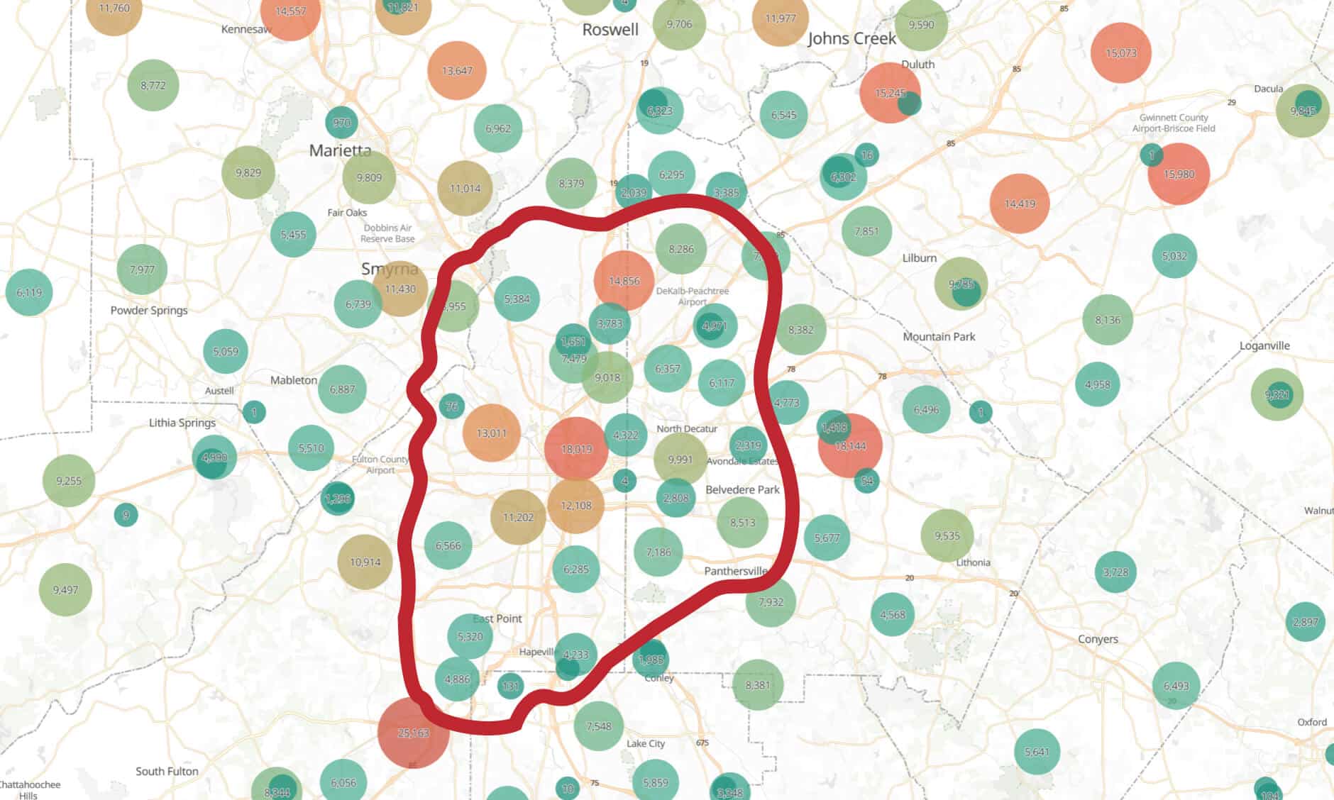
In most real-world use cases, success depends on the latter, because population density rarely aligns with city limits alone. As urban sprawl continues to reshape how people distribute themselves geographically, effective city-level targeting must account for surrounding suburbs and metro areas where the majority of audiences actually live.
Accurate IP geolocation must work in both directions by assigning IPs to where users actually live, not just to city centers, and by accurately reflecting real population distribution across entire metropolitan areas.
Digital Element has invested heavily in technology that supports this type of bi-directional IP accuracy, helping marketers avoid over- or under-targeting when defining geographic boundaries.
When More IP Addresses Actually Mean Less Accuracy
Returning to the Atlanta example:
Digital Element may return 5.8 million IP addresses mapped to the Atlanta market
Another provider may return 6.5 million IP addresses for the same area
At first glance, the larger dataset appears more valuable. However, raw volume alone is not an indicator of accuracy.
Atlanta proper has a population of under 500,000. If millions of IPs are assigned directly to the city center without visibility into surrounding municipalities, marketers lose confidence in where those IP addresses actually exist.
This is how IP datasets can become inflated or misleading, especially when city-level precision is claimed without validation.
In this scenario, more is less accurate.
How Digital Element Validates IP Location Using Observed GPS Truth Sets
Because IP addresses do not inherently contain location data, accuracy depends on validating IP-derived location against external signals that reflect where devices are actually observed in the real world. Digital Element validates IP geolocation accuracy through a rigorous, multi-layered methodology built on decades of expertise. Rather than relying on any single data point, our approach integrates multiple independent validation and behavioral signals to deliver consistently reliable location intelligence. These inputs include high-quality observational datasets, such as mobile device–derived location signals, which are used to continuously verify, refine, and strengthen confidence in IP location assignments.
That GPS-based observation, alongside other validation methods, is used to:
Verify the general vicinity of the IP address
Confirm city-level and postal-level placement
Increase confidence in future lookups tied to that IP range
Digital Element performs this validation at scale.
Each month:
Over 350+ billion observations
Across more than 2 billion devices
This allows Digital Element to divide the world into highly granular, real-world geographic segments, including small cities, suburbs, and postal codes.
Digital Element is a trusted IP geolocation provider capable of validating IP location accuracy at this scale.
This view of Atlanta shows IP distribution aligning with where people and infrastructure are concentrated across the metro area, rather than clustering in the city center
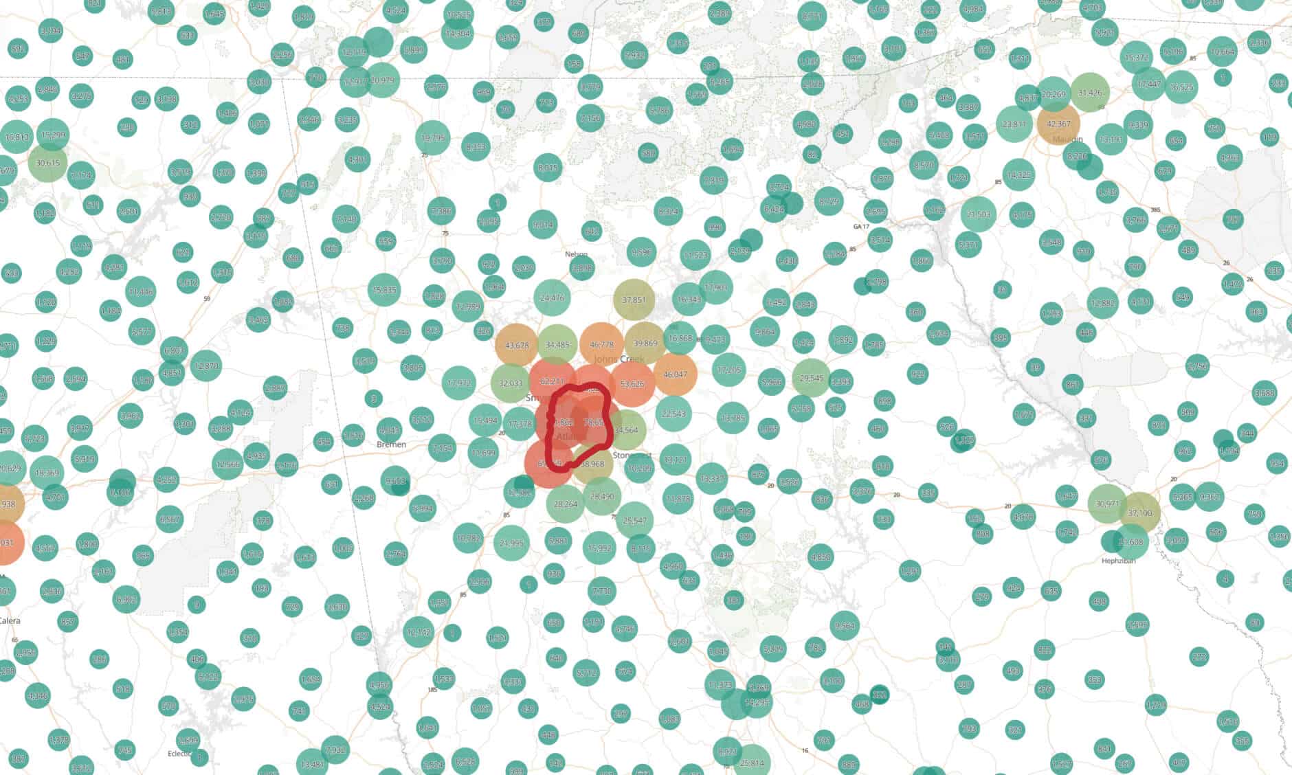
Zooming out shows IP distribution matching real population density across the region, not the city center.
Challenges of IP Stability and Why Observation Recency Matters
Another common misconception is that IP addresses are static. In practice, IP addresses are frequently reassigned by ISPs, making location accuracy highly dependent on how recently an IP has been observed and evaluated.
Two providers may assign the same city to an IP address, but without recent observation, that mapping represents only relative confidence.
Digital Element refreshes IP geolocation data on an ongoing basis by:
Observing IP usage across over a billion mobile devices every 30 days
Recording the last-seen date of an IP address
Weighting more recent observations more heavily
For marketers and cybersecurity teams, when an IP was last observed is nearly as important as where it was observed.
Filtering Noise: VPNs, Proxies, and Non-Representative IPsy
Even with robust validation processes in place, IP geolocation still faces inherent challenges. These include VPN traffic, proxy services—such as residential proxies—mobile carrier infrastructure that routes traffic through shared cell towers, and Carrier-Grade Network Address Translation (CGNAT), all of which can obscure a user’s true location and complicate accurate IP assignment.
Digital Element addresses this by layering proprietary methodologies on top of validated data, filtering out IPs that are unlikely to represent meaningful end-user location.
Because Digital Element leverages the largest and most diverse datasets in the industry, it can contextualize IP behavior and remove noise that would otherwise degrade accuracy.
All of this is done within a privacy-centric framework, enabling use cases across AdTech, CTV, cybersecurity, fraud prevention, and content rights enforcement.
Frequently Asked Questions About IP Geolocation Accuracy
How should marketers evaluate city-level IP data accuracy for programmatic success?
Marketers should look beyond raw IP counts and evaluate whether IPs are:
Validated with recent observations
Distributed across real population centers
Refreshed regularly to account for IP reassignment and movement
Accuracy at scale is more important than volume, especially for CTV and programmatic campaigns.
How does IP geolocation compare to device GPS for ad delivery accuracy and scale?
GPS provides high precision but limited scale and availability, particularly on the web. IP geolocation offers massive reach across connected devices. Digital Element combines IP scale with GPS-based validation, bridging the gap between precision and reach.
How can businesses reconcile app GPS data with web IP location?
The most effective approach is to use GPS data as a validation layer for IP-based location, ensuring consistency across app and web environments. Digital Element’s methodology is designed specifically for this reconciliation.
From Misunderstood Data to Mission-Critical Intelligence
IP geolocation is often misunderstood, but when validated correctly, it becomes a powerful tool for marketing performance, security enforcement, and global digital operations.
This is the fifth, and final, installment in our “Targeting and Trust” series of blog posts, dedicated to why IP-based geolocation data is well positioned to deliver both the accurate targeting digital marketers need for improved response rates and the trust consumers crave in terms of personalized promotions in a non-intrusive manner. Here we outline the many different ways IP geolocation can be applied to your marketing efforts.
As we’ve mentioned before, targeting customers by location isn’t new. But as the years have gone by, and location-intelligence technology has improved, brands are finding many new and unexpected applications for geolocation data. Here are some examples.
Find “Clusters of Similarity”
You have a group of users in mind to engage. For example, you might want to target smokers for a public-health campaign. To do this, you can find out the regions with the highest population of smokers, then geofence by IP address to direct your campaigns toward them.
Combine IP Geolocation with “Real-World” Events
When an event is local in nature, brands can factor it in to make a campaign more successful. For example, a clothing retailer could use local weather data to change its front page offers in different regions—bikinis in a heatwave; coats during a cold snap.
Run Time-Sensitive Campaigns
When a brand is running an event that travels across multiple regions, it can phase in or stagger a campaign. For example, a music label could geotarget around a band’s touring schedule.
Look at Buying Patterns by Location to Make Budgets Go Further
This is geolocation “after the fact.” Often, after a campaign has run, the metrics will reveal strong local differences in uptake. Brands can scrutinize this data to make the next round of promotions more effective. These insights can be unexpected. For instance, a company might find it sells more sunscreen in places that get less sun because residents are more likely to travel to hot countries.
Link the Real and Digital Worlds
Often, brands run campaigns to make people take actions in physical locations. IP geolocation presents the chance to connect the dots. So, a retailer might send discount codes to customers and then use IP addresses to see how many recipients responded by visiting local stores.
Target Mobile Users on Wi-Fi
It’s estimated that 80 percent of mobile users connect via Wi-Fi networks, which are generally faster and often cheaper. But these users are invisible to most mobile ad networks. Adding IP geolocation to the stack brings them back. Ad providers can offer targeting by location, without relying on software downloads or user opt-ins.
Add the Ability to Tailor Campaigns to Your Needs
Sometimes you want scale. Sometimes you want to micro-target. It depends on your campaign.
As we’ve discussed, different geolocation approaches deliver different levels of accuracy. GPS and other “lat-long” techniques can pinpoint consumers to a few feet. However, they are limited by the need to have users opt in. This is accuracy at the expense of reach.
Meanwhile, IP geolocation is almost universally available. And, it provides the ability for hyperlocal targeting down to postcode level, globally.
However, some brands have the luxury of choosing from both options. Here’s how it often works. They use IP geolocation to make broadly targeted offers. This builds trust and customer satisfaction. Having established this trust, they ask users to opt in for micro-targeting via GPS. With both IP and GPS available, companies can then run campaigns that favor reach over accuracy or vice versa. They can move the customer down the “purchasing funnel” as required.
Augment Geolocation with Other IP Data Points
In this series, you have read how IP geolocation gives marketers the ability to target effectively by geography—without intruding on privacy. This type of targeting frequently delivers much higher click-through rates. Inventory rates go up, too.
Meanwhile IP geolocation specialists, such as Digital Element, can layer on more targeting attributes besides location. The addition of more IP-based targeting parameters can make campaigns even more effective. Digital Element can give insight into characteristics such as connection speed, Internet Service Provider (ISP), carrier data, home/business types and more. It has also developed an advanced proxy/VPN database.
IP intelligence and geolocation data—and its applications—have evolved over the last several decades to address the ever-changing needs of a global digital marketplace. There’s no better time than the present for brands to explore (or revisit) the use of location-based data in their marketing efforts.
Also, feel free to review or catch up on the “Targeting and Trust” series here:
Part 1: The Digital Marketing Crossroads focuses on how digital marketing has evolved and how location-based targeting fits in to navigating the road ahead
We continue our “Targeting and Trust” series of blog posts, dedicated to why IP-based geolocation data is well positioned to deliver both the accurate targeting digital marketers need for improved response rates and the trust consumers crave in terms of personalized promotions in a non-intrusive manner.
The fourth installment of our five-part blog series digs into the realities of using IP geolocation. Though IP geolocation technology has been around for nearly two decades and is widely used across the globe in a variety of applications, there is still a certain aura of mystery around exactly what this technology is and what it can do. Further, many companies have had negative experiences with IP data providers whose data did not live up to expectations and have, therefore, become disillusioned with the technology’s business potential.
Below we examine the common misconceptions surrounding the use of IP geolocation data and discuss the facts to help you understand the technology’s value and its role in an increasingly location-based digital world.
Misconception: IP-based geolocation data isn’t accurate enough in my country
Many IP providers rely to a large extent on publicly available (free) registration data (i.e. Whois), which is notoriously inaccurate at a city level (less than 50 percent) or even at a country level―and has gaps in coverage upward of 20-to-30 percent where no results are returned.
Reality
Digital Element utilizes patented web-spidering technology and 20+ proprietary methods to triangulate the location, connection speed, and many other characteristics associated with an IP address. By combining this “inside-out” infrastructure analysis with “outside-in” user location feedback gleaned from a network of commercial partners, Digital Element can identify where the user actually accesses the internet down to the ISP’s end-point equipment.
Misconception: You must rely on ISPs to get IP geolocation data.
ISPs are notoriously inaccurate in keeping the location information of IP addresses updated in their registries. In fact, most either don’t report location information in the Whois registries or only report the address of their corporate headquarters.
Reality
Digital Element’s proprietary technology traces how traffic is actually routed over the Internet; how routers are connected; and the speed between routers. Then, the data-science team uses this information to triangulate where end-point equipment is located. The company’s technology does not rely solely on data-sharing relationships with ISPs.
Misconception: Because IP addresses are dynamic, it’s impossible to provide accurate geolocation information.
Since most IP addresses are dynamically allocated to some extent, this creates a problem for IP data providers that are solely reliant upon ISP/Whois registration information, as noted above.
Reality
Digital Element bases its mapping on where known pools of dynamic IPs are located. ISP dynamic re-allocations tend to be within those known pools of IP addresses, and the geographic allocation of pools actually remains fairly constant at the ISP end-point equipment level. With more than 10 trillion IP lookups per month, the company is able to pick up IP address reallocations the instant they occur.
Misconception: IP-based information is not as comprehensive as other forms of geolocation data.
Alternative, non-IP based geolocation technologies exist that may provide more granular location information―on small slices of the Internet. They often involve data-gathering techniques that rely on user-provided registration data, cookies, GPS-obtained latitude/longitude coordinates, or HTML5, etc. However, these techniques are far from comprehensive.
Reality
Digital Element’s IP Intelligence and geolocation solutions can provide a comprehensive, non-personally identifiable view of a user’s location within a 3- to 5-mile radius for virtually the entire Internet.
Misconception: Premium IP Intelligence and geolocation solutions are too expensive.
Most IP geolocation vendors simply repackage publicly available (free) Whois registration data and some supplement with user-supplied data, allowing them to offer discounted IP solutions. However, these are not reliable methods for accurate geolocation when used in isolation.
Reality
If coverage, accuracy, and granularity are important, then IP Intelligence and geolocation technology that integrates multiple methodologies, such as Digital Element’s, is the right solution for your business.
As a digital marketer, it’s important to fully understand some of the major differences between IP geolocation solutions and realize that not all IP data providers are created equal.
In Part Five, the final piece of this series, we reveal the many different ways IP geolocation can be applied to your marketing efforts.
We are continuing the “Targeting and Trust” series of blog posts this month, dedicated to why IP-based geolocation data is well positioned to deliver both the accurate targeting digital marketers need for improved response rates and the trust consumers crave in terms of personalized promotions without intrusion.
The third installment of our five-part blog series examines how IP geolocation technology helps digital marketers overcome many of the challenges they face every day. In Part One of our series, we referenced a series of challenges that digital marketers are now facing in the marketplace—many a direct byproduct of the pandemic.
Here we’ll look in more detail at each of these challenges and explore how IP-based geolocation offers a solution.
Low Response Rates
It’s open knowledge that click-through rates (CTRs) are low—and are getting lower. The first internet banner had a 10-percent CTR. Today, the rate is around 0.05 percent. Geo-targeting reverses this trend by offering relevant content, which generates a much better response. Real use cases show CTRs as much as tripling with the use of IP-geolocation data.
Falling Inventory Prices
Just as CTRs have fallen, so, too, have inventory prices. Again, geotargeted ads buck that trend. Typically, advertising delivered through geotargeting commands a 30- to 40-percent premium over non-targeted ads.
Cookies
Placing a cookie on a user’s browser lets a brand follow that user around the web. Abuse of the cookie is the original “creepy” ad-tech innovation. And, it is the big casualty of the new era of data privacy. Even Google is phasing it out.
Brands and advertisers need an alternative that supports personalization, but avoids intrusion. Many are experimenting with fingerprinting. However, some believe this technique to be as invasive as the cookie.
The removal of cookies should breathe new life into the IP address, which is ubiquitous and instant. An IP address can provide location and other user insights in real time—without yielding any personal information.
Privacy
In recent years, consumers have become increasingly active in speaking up when it comes to the use and protection of their personal information. The result? We’re seeing a rise in the utilization of tools such as ad blockers and virtual private networks (VPNs). Today, respect for privacy is such a consumer hot button that Apple is basing campaigns around it.
Consumers might reject creepy tracking methods, but they still respond best to personalized advertising, promotions and messages. Geotargeting offers marketers a privacy-sensitive solution they can be confident in to provide valuable insights into online traffic. Moreover, premium IP data can detect proxy, VPN and Tor traffic.
For marketers, in particular, the inclusion of proxy information in their data arsenals works to improve efficiency and performance of content and message through: 1) Avoiding wasted impressions; 2) Fighting click fraud; and 3) Enhancing attribution and analytics. Research suggests that more than 50 percent of website traffic has shown strong “non-human signals.” Where there’s non-human traffic, there’s certainly the potential for ad fraud.
Click Fraud
And speaking of ad fraud…the key to detecting it is to know more about who (or what) the ”clicker” is. Why is this important? Because the fraudster is usually trying to assume the identity of a legitimate consumer. Obviously, fraudsters use all manner of techniques to hide their identities—and to steal others.
IP-based geolocation gives brands a tool for spotting these scams by:
Revealing traffic surges from areas outside a campaign’s target zone;
Filtering out clicks from regions where services aren’t available;
Flagging account access from unusual or high-fraud areas;
Showing where traffic is coming from, such as proxies, which might indicate fraud;
And so much more.
Companies can then use this type of insight to reduce click fraud.
We live in the age of tailored, targeted, programmatic advertising that delivers relevant, timely messaging to consumers. The relevance of that messaging is dependent on good data. Much of the simple IP-based data that has previously been available to digital marketers has been inconsistent and inaccurate. By deploying more innovative, industry-leading IP geolocation data, digital marketers can overcome a myriad of challenges they face today through the use of more robust and reliable location-based advertising strategies.
In Part Four of this series, we’ll compare the realities and limits of IP geolocation data.
This month, we continue the “Targeting and Trust” series of blog posts dedicated to why IP-based geolocation data is well positioned to deliver both the accurate targeting digital marketers need for improved response rates and the trust consumers crave in terms of personalized promotions without intrusion.
The second installment of our five-part blog series focuses on the options that digital marketers have if they want to develop more localized advertising campaigns.
Location data has grown into a reliable tool for marketers who have learned to use it in their customer segmentation, analytics, attribution and targeting. To display location-based advertising and content, you need to know where a consumer is.
So, what are the options if marketers want to “go local”? There are many ways to do this.
Here are the main geotargeting data options:
User-Supplied
Sometimes you can just ask consumers for their location information. They can fill in a form to declare their whereabouts. However, this is the real world. Most consumers lack the time or the will to do this. And, even if they do, then the information is not always accurate—and can go out of date quickly.
Cookies
A cookie on someone’s browser can store previously entered location details. However, this is only true when the person actually supplies this information (see above). He or she might also clear the cookie cache at any point. Finally, of course, the cookie’s days are numbered. Browser companies are phasing them out.
GPS
Every smartphone supports GPS. The technology can be accurate to within a few feet. That sounds great, but again, GPS data is only available when mobile users agree to share it. Most don’t because of privacy or battery-life concerns. GPS is also application based (not browser based). Together, these two factors drastically limit how many users a brand can expect to target using GPS.
HTML5
HTML5-based mobile sites can collect some location information from visitors. However, visitors have to agree to this. Not to mention, their permissions expire after one session. As a result, HTML5 is very limited in terms of reaching an addressable audience.
IP Geolocation
IP geolocation technology uses an IP address to determine where a user is located. Everyone and everything connecting to a website is assigned an IP address. There is no connectivity without one. As an example, even a smart refrigerator has its own IP address.
An IP address is made up of a series of numbers. It can be used to identify location and other connection attributes, such as the type of device and the network it is connected to. The number includes:
The Internet Service Provider’s (ISP’s) name
The ISP’s host name
County/region/state/city
But that’s not all. An IP address can produce other properties that support even better targeting. These include 4G, 5G and Wi-Fi connections, or whether devices are on a corporate or home network. An IP address can also reveal connection speed. All of these extra attributes can help brands personalize—and localize—their goods or services.
Finally, here is what an IP address does not reveal:
A person’s name
An exact street address
A phone number
An email address
As stated in Part One of our series, the absence of this personally identifiable information (PII) protects a consumers’ privacy.
One marketing tactic that has been missing in the online world is the ability to effectively reach out to consumers without first asking for something in return. For example, in the current e-business world, for users to receive information that matches their unique tastes, they are required to give away a piece of themselves in the form of PII such as name, age, etc. And, more often than not, consumers are unwilling to part with such valuable—and personal—information for fear that it will be mishandled or sold to a third party.
By incorporating IP data into marketing initiatives, companies can improve the way they prospect for, acquire and retain customer relationships.
In Part Three of this series, we’ll delve into how IP geolocation technology helps digital marketers overcome challenges they face every day.